
Ipsos Guide
Ipsos Guide — Beach, Nightlife and the Road to Pantokrator
Ipsos is a resort village on the east coast of Corfu, about 14 km north of Corfu Town. It runs along a shingle bay of roughly 2 km beneath the slopes of Mount Pantokrator, and combines a lively evening strip with the island’s most direct access to the mountain.
Ipsos sits where the flat coastal road ends and the corniche north begins, with Pyrgi at its northern end. That position gives the village two characters at once: a beachfront resort with bars and watersports, and the gateway to the highest ground on Corfu. This guide covers the beach, the nightlife, the surroundings and the practical points.
Where is Ipsos and how do you get there?
Ipsos lies about 14 km north of Corfu Airport and 12 km north of Corfu Town, on the east coast. Dassia sits 2 km south, Gouvia 5 km south and Barbati 5 km north. Buses run from Corfu Town rather than from the airport.
The village occupies the northern end of the sheltered stretch of east coast, where the shoreline begins to climb against the Pantokrator massif. Everything south of it is flat coastal road; everything north is corniche.
| Destination | Approximate road distance from Ipsos |
|---|---|
| Dassia | 2 km |
| Kommeno | 4 km |
| Gouvia | 5 km |
| Barbati | 5 km |
| Kontokali | 7 km |
| Nissaki | 8 km |
| Corfu Port | 10 km |
| Corfu Town | 12 km |
| Corfu Airport | 14 km |
| Kassiopi | 22 km |
| Paleokastritsa | 23 km |
| Acharavi | 25 km |
| Sidari | 27 km |
Transport into Ipsos runs three ways. The KTEL intercity bus network reaches the village from the bus station in Corfu Town, so an airport arrival transfers into town first. Taxis run directly from the terminal. A hire car covers the 14 km in around twenty-five minutes and then serves the rest of the stay, which is set out on the Ipsos Car Rental page.
What is Ipsos beach like?
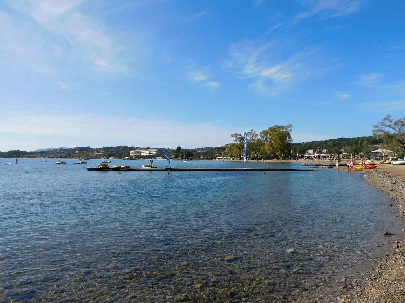
Ipsos beach runs roughly 2 km along the coastal road as a mix of shingle and sand, shelving into shallow, clear water. The mix underfoot is comfortable in many stretches, and the shallow entry suits families with children.
The beach is the village’s defining feature and it runs the whole length of the settlement, separated from the accommodation only by the road.
Four characteristics define it.
- Walk a shoreline of about 2 km, long enough that the busy and quiet ends differ noticeably
- Enter shallow, clear water that shelves gently, which is why the bay suits younger swimmers
- Find sunbeds, umbrellas and beach bars along the developed central stretch
- Expect shingle mixed with sand rather than a continuous sand beach
Watersports concentrate on the central section. Operators along the front rent pedalos, paddleboards and equipment, and jet skiing, parasailing and diving all run from the bay. A diving school operates in the area, and dolphins are sighted offshore on occasion.
The northern end toward Pyrgi is quieter than the centre, and the water clears further as the coast turns toward Barbati. Anyone wanting the clearest swimming on this coast drives the 5 km north.
What is the nightlife like in Ipsos?
Ipsos carries one of the livelier evening strips on the east coast, with bars and clubs along the beachfront road. It combines that with a village setting, so the noise concentrates on the central section rather than the whole bay.
The village is among the more commercial spots on the island, and the evening economy is a large part of why people choose it.
The strip runs along the road behind the beach. Bars, tavernas and disco bars sit together on the central section, and the activity continues late through the summer months. Live music and open-fronted bars face the water.
Two things temper the picture. The busy section is a defined stretch rather than the whole 2 km, so accommodation at either end sits away from it. And the season shapes it sharply: July and August carry the full strip, while May and October run at village pace.
The practical consequence for a driver is worth noting. Pedestrians use the beachfront road late into the night, and scooters and quad bikes run in volume through the season. Slower running through the village after dark is the sensible response.
How do you get from Ipsos to Mount Pantokrator?
The summit road climbs to 906 metres in sustained hairpins from the coast north of Ipsos, passing the village of Spartilas in olive terraces. Pantokrator is the highest point on Corfu, with a monastery at the top.
The mountain is the reason Ipsos differs from the resorts south of it. The climb starts within minutes of the beach, and no other resort base offers it as directly.
Four points shape the drive.
- Fill the fuel tank before starting, because a sustained climb consumes more than the distance suggests
- Allow more time than the distance implies, because average speed falls sharply on the bends
- Keep to the sealed road, since loose stone on the side tracks damages tyres and undercarriage
- Use engine braking on the descent rather than continuous brake pressure
Spartilas makes a natural halfway stop, set in olive terraces with the view back over the Ipsos bay. The summit itself looks across the whole island, over the channel to the Albanian mainland and, in clear conditions, far down the Ionian.
The road is the most demanding a visitor based here is likely to drive, and it is also the single best half-day the location offers.
What is there to see around Ipsos?
The corniche north reaches Barbati at 5 km, Nissaki at 8 km and Kassiopi at 22 km. Inland, Spartilas, Ano Korakiana and Agios Markos hold traditional village life within a short climb.
The village works as a base because two very different landscapes meet at it.
North — the corniche and the clear water
The road climbs above the shoreline past Barbati and Nissaki, where white pebble beaches sit below and the water is the clearest on the east coast. Kalami and Agios Stefanos follow in sheltered inlets, and Kassiopi at 22 km holds a working harbour beneath a ruined castle.
Inland — the hill villages
Ano Korakiana and Agios Markos sit in the hills behind the coast and offer a view of Corfiot village life away from the resorts. Spartilas lies on the Pantokrator road in olive terraces.
South — the resorts and the capital
Dassia at 2 km, Gouvia at 5 km and Kontokali at 7 km run along the coast toward Corfu Town at 12 km, with its UNESCO old quarter and both fortresses.
West — the crossing to the open sea
Paleokastritsa at 23 km sits across the island, where the bay divides into coves beneath wooded headlands with boat trips to the sea caves.
Route ideas across the island sit in Best Scenic Drives In Corfu Island: 8 Stunning Road Trips For Coastal Views, Villages And Hidden Bays.
What is the corniche road north of Ipsos like?
The coastal road north of Ipsos climbs above the shoreline against the Pantokrator slopes, passing Barbati, Nissaki, Kalami and Agios Stefanos before reaching Kassiopi at 22 km. The channel toward Albania stays in view throughout.
This is the drive that most rewards a stay in Ipsos, and it changes character within the first two kilometres of leaving the village.
Five stages structure it.
- Leave Ipsos through Pyrgi, where the flat coastal strip ends and the climb begins
- Pass Barbati at 5 km, where white pebble beaches sit below the road
- Continue through Nissaki at 8 km, with small coves reached by steep side turnings
- Drop to Kalami and Agios Stefanos, the sheltered inlets on the north-east corner
- Reach Kassiopi at 22 km, a working harbour village beneath a ruined castle
Three driving conditions apply along it. The carriageway narrows where it is cut into the hillside, and oncoming traffic negotiates passing places on the tighter sections. Blind bends carry a drop on the seaward side. The side turnings down to the coves are steep and, in places, unsealed.
The Albanian mainland sits across a narrow channel for the whole route, which is what gives the drive its character. On a clear day the far shore reads as close enough to touch.
What villages sit inland from Ipsos?
Spartilas lies on the Pantokrator road in olive terraces above the bay. Ano Korakiana and Agios Markos sit in the hills behind the coast, both within a short climb from the shoreline.
The hills behind Ipsos hold a very different Corfu from the beachfront, and the contrast is reachable in twenty minutes.
Spartilas
Set in terraced olive groves on the road up to Pantokrator, Spartilas looks back down over the Ipsos bay and the channel. It functions as the natural halfway stop on the summit drive.
Ano Korakiana
A hillside village behind the coast, spread along a slope with a long main street and views over the eastern shore. It holds a settled village life rather than a tourist economy.
Agios Markos
Rising in tiers above the coastal plain, the village looks out over the bay from close range and offers a short climb rather than a full excursion.
The roads to all three narrow quickly once they leave the coast, with olive trees meeting the carriageway and few passing places. Slower running and attention to oncoming traffic answer that directly, and a shorter car handles the lanes more comfortably than a long one.
Visiting the villages in the late afternoon puts the light behind the coast and the temperature at its most workable, which suits both walking and photography.
How does Ipsos compare with the other east-coast resorts?
Ipsos sits furthest north of the main east-coast resorts, which shortens the run to Pantokrator and the corniche. Dassia and Gouvia sit closer to Corfu Town and the airport, and both are quieter in the evening.
Four resorts share this stretch of coast within 7 km of each other, and the differences are real rather than cosmetic.
Kontokali at 7 km is the closest to the capital and the quietest of the four, a working village beside the marina rather than a beach resort.
Gouvia at 5 km holds the island’s largest marina and a resort frontage, with a shallow sheltered bay suited to small children.
Dassia at 2 km carries the longest shingle beach of the group, backed by olive groves that give afternoon shade, and draws family holidays.
Ipsos carries the liveliest evening strip and the shortest access to the mountain and the north-east coves.
Three considerations decide between them.
- Weigh evening activity, which peaks at Ipsos and falls steadily southward
- Weigh proximity to Corfu Town and the airport, which improves southward
- Weigh access to Pantokrator and the corniche, which is best from Ipsos
All four sit on the same road within fifteen minutes of each other, so a car makes the choice less binding than it looks. Details sit on the Dassia Car Rental and Gouvia Car Rental pages.
Who does Ipsos suit as a holiday base?
Ipsos suits families wanting shallow, safe swimming, groups wanting an evening strip, and drivers wanting the shortest access on the island to Mount Pantokrator and the north-east corniche.
The village covers a wider range of visitors than its reputation for nightlife suggests, because the bay and the mountain serve different people.
Families take the shallow, gently shelving water and the length of the beach, which puts distance between the quieter ends and the central strip. Watersports and the diving school add structure to a week.
Groups take the evening economy, which is among the liveliest on this coast, and the concentration of bars within walking distance of the accommodation.
Drivers and walkers take the position. Pantokrator starts here, the corniche to Kassiopi starts here, and the hill villages sit twenty minutes inland.
The trade-off is that Ipsos is a resort rather than a village that happens to have visitors. Anyone wanting quiet on the doorstep looks 4 km south to Kommeno or further north to Barbati and Nissaki, both covered on the Kommeno Car Rental page and reachable in minutes from here.
What day trips work from Ipsos?
Three day trips run comfortably from Ipsos: the corniche north to Kassiopi at 22 km, the summit circuit over Pantokrator, and the crossing west to Paleokastritsa at 23 km.
The village’s position at the junction of coast and mountain means the three leave in genuinely different directions and each returns without a long transfer.
The corniche and the north coast
Follow the coast past Barbati, Nissaki, Kalami and Agios Stefanos to Kassiopi at 22 km, then turn west along the north coast to Acharavi at 25 km and Roda at 26 km. Sidari at 27 km closes the loop on the north-west corner. The return runs inland or retraces the coast.
The mountain circuit
Climb through Spartilas to the Pantokrator summit at 906 metres, with the monastery at the top and views over the island, the channel and the Ionian. Descend by the northern route toward Acharavi to make a circuit rather than retracing the climb.
The west-coast crossing
Cross the island to Paleokastritsa at 23 km, where the bay divides into coves beneath wooded headlands and boats run to the sea caves. Climb to Lakones on the ridge, continue to the Byzantine fortress at Angelokastro, and return south through Pelekas at 18 km.
Fuel planning differs by trip. The corniche and the mountain circuit both pass few stations once past Barbati, so both justify filling in the village or at Dassia before departure. The west-coast crossing stays nearer the eastern corridor for its first half.
Village-by-village detail sits in Car Hire For Exploring Corfu Villages: The Smartest Way To See The Island.
What is the history of Ipsos and this coast?
Ipsos grew from a fishing settlement on the sheltered east coast into a resort during the second half of the twentieth century. The olive terraces behind it date from the Venetian centuries, when Venice encouraged olive planting across Corfu.
The village’s shape reflects two very different periods, and both are still visible from the beach road.
The olive groves climbing behind the coast are the older layer. Venice held Corfu for roughly four centuries and promoted olive cultivation across the island, which is why the interior carries terraced groves rather than the scrub common on drier Greek islands. Those terraces are what make the hills behind Ipsos green rather than bare.
The resort frontage is the recent layer. Package tourism reached this stretch of coast in the later twentieth century, and the flat land between the shoreline and the slopes made it straightforward to build along. The result is a settlement that is linear by geography rather than by design.
Pyrgi at the northern end marks the older core of the settlement, where the road begins to climb. The hill villages inland — Spartilas, Ano Korakiana, Agios Markos — preserve the pattern the coast had before the resorts, with houses stacked on slopes and agriculture rather than tourism as the economy.
Mount Pantokrator above it all carries a monastery at the summit, and the mountain has been a landmark for shipping in the channel for as long as the channel has been sailed.
When is the best time to visit Ipsos?
July and August carry the fullest strip and the warmest sea, with the heaviest crowds. May, June, September and October offer warm weather, open businesses and a quieter village.
The village’s seasonal swing is wider than most on Corfu, because so much of its character depends on the evening economy being open.
Peak — July and August
Every bar, watersport operator and taverna runs. The beach and the strip are at their busiest, and the coastal road slows at midday and in the early evening.
Shoulder — May, June, September, October
Weather suits both swimming and the mountain roads, and the village runs at a comfortable pace. September holds the warmest sea of the shoulder months.
Winter — November to March
Seasonal businesses close and the village returns to residential life. The Pantokrator road and the corniche stay open and run empty, which suits a driving visit rather than a beach one.
Anyone coming specifically for the mountain and the villages finds the shoulder months better than the peak, because the roads are clear and the walking temperatures are workable.
What are the practicalities of a stay in Ipsos?
Shops, tavernas, bars and watersports sit along the beachfront road. Fuel stations concentrate south toward Dassia and Gouvia and thin north of the village. Buses run to Corfu Town rather than to the airport.
The village handles day-to-day needs on its own and relies on the corridor south for the rest.
- Find supermarkets, tavernas, bars and beach services along the frontage
- Fill the car south toward Dassia and Gouvia, because coverage thins past Barbati
- Take the KTEL bus from Corfu Town for intercity journeys, since routes radiate from there
- Carry cash for the inland villages, where card payment is less consistent than on the coast
Parking is straightforward compared with the capital. Accommodation along the frontage carries its own space, and roadside parking runs beside the beach, filling through the middle of the day in high season.
Medical and banking services sit in Corfu Town, 12 km south, along with the ferry port and the airport.
Ipsos — frequently asked questions
Where is Ipsos in Corfu?
Ipsos sits on the east coast about 14 km north of Corfu Airport and 12 km north of Corfu Town, at the point where the flat coastal road meets the corniche climbing beneath Mount Pantokrator. Dassia lies 2 km south and Barbati 5 km north.
Is Ipsos beach sandy or pebbly?
The beach is a mix of shingle and sand running roughly 2 km along the coastal road. The mix is comfortable underfoot in many stretches, and the water shelves gently into a shallow, clear entry that suits families with children.
Is Ipsos good for families?
The shallow, gently shelving water and the length of the beach suit families, and watersports along the front add structure to a week. The central strip carries the evening bars, so accommodation at either end sits away from the noise.
Is Ipsos noisy at night?
The evening strip concentrates on the central section of the beachfront road rather than along the whole bay, with bars and disco bars running late through July and August. May and October run at village pace by comparison.
What watersports are available at Ipsos?
Operators along the front rent pedalos, paddleboards and equipment, and jet skiing, parasailing and diving all run from the bay. A diving school operates in the area, and dolphins are sighted offshore from time to time.
How do you get from Ipsos to Mount Pantokrator?
The summit road climbs from the coast north of the village to 906 metres in sustained hairpins, passing Spartilas in olive terraces. A full fuel tank before starting matters more than the distance, because the sustained climb consumes heavily.
How far is Ipsos from Corfu Town?
Corfu Town sits about 12 km south along the coastal road, roughly twenty minutes outside peak traffic. Corfu Port lies 10 km south and Corfu Airport 14 km south, both on the same route through Dassia, Gouvia and Kontokali.
Which beaches near Ipsos have the clearest water?
Barbati at 5 km and Nissaki at 8 km hold the clearest water on the east coast, sitting on white pebble beneath the Pantokrator slopes. The clarity improves noticeably as the coast turns north past Pyrgi.
Do buses run from Ipsos to Corfu Airport?
The KTEL intercity network radiates from the bus station in Corfu Town rather than from the airport, so a bus journey involves a transfer in the capital. A taxi or a hire car covers the 14 km directly.
Is Ipsos worth visiting outside the summer?
Seasonal businesses close from November to March, so the strip and the watersports are unavailable. The Pantokrator road, the corniche north and the inland villages stay open and run empty, which suits a driving or walking visit.
Which villages are near Ipsos inland?
Ano Korakiana and Agios Markos sit in the hills behind the coast and show Corfiot village life away from the resorts. Spartilas lies on the Pantokrator road in olive terraces with views back over the bay.
Is parking easy in Ipsos?
Accommodation along the frontage carries its own parking, and roadside space runs beside the beach. Both fill through the middle of the day in July and August, when the beachfront road also slows with pedestrian traffic.
Can you walk from Ipsos to Dassia?
Dassia sits 2 km south along the coastal road, which is walkable in around half an hour on level ground. The route runs beside the carriageway rather than on a separate footway for parts of it, so daylight and attention to traffic matter on the walk.
Are there dolphins off Ipsos?
Dolphins are sighted offshore from the bay on occasion, most often from boats rather than the beach. The diving school and the watersports operators along the front are the people who see them most, and sightings are opportunistic rather than reliable.
Is Ipsos suitable for a quiet holiday?
The central strip carries the bars and runs late through July and August, so a quiet stay means accommodation at either end of the 2 km bay, or a base a few kilometres away. Kommeno at 4 km and Barbati at 5 km both offer markedly quieter settings within minutes by road.
The island as a whole is covered on the Corfu Airport Rent a Car guide, and rates for Corfu Airport Cars sit on the home page.
Which other Corfu locations and guides are worth reading?
Triple Seven covers seven pick-up locations across Corfu and publishes a travel guide for each of them. The rental pages carry rates, delivery and terms; the guides carry the place itself.
Corfu car rental locations
- Gouvia Car Rental
- Corfu Town Car Rental
- Corfu Port Car Rental
- Ipsos Car Rental
- Dassia Car Rental
- Kommeno Car Rental
- Kontokali Car Rental
Corfu travel guides
- Corfu Airport (CFU) Guide
- Corfu Port Guide
- Corfu Town Guide
- Dassia Guide
- Gouvia Guide
- Kommeno Guide
- Kontokali Guide